Introduction
We encourage you to verify the source images for yourself, rather than just simply accept the facts that are presented here.
Exact details of the used image templates can be found here.
Some reports on this website are based on previous ones. So it is extremely important to read the reports in chronological order.
Details can turn up that probably have been analyzed in detail. If you are new here and you directly start reading the
recent reports without prior knowledge, then it could happen that the required context is not recognizable.
You do yourself and us a favor when you first start with the oldest reports.
This report is directly referenced to structure anomalies that have been discovered in the Terby Crater. We recommend that you first
review the previous report, if you have not read it yet.
This includes the following document:
1. Mars Geoglyphs analogous to the Nazca plain
The Terby Geoglyphs as Hint Giver
It is one of these rare opportunities that offer the opportunity to draw parallels. Parallels which show that
certain elements of human cultural history can not only be found on Earth. What this means, can
currently not be clearly specified. There are still not enough pieces of the puzzle to recognize how the big picture looks like.
The Terby geoglyphs point to an important symbolism. They are a sign, a hint giver, created to be already seen from afar.
The observer, however, has to look down from a bird's eye view to recognize the geoglyphs. So, we owe it to one single spacecraft,
that we can look at this image.
An first interpretation of the represented figures was already part of a previous report
(The Dragon in the Terby Crater). A further analysis of this symbolism
is part of another report that will follow soon.
The following images show the discovered geoglyph pair and the reconstruction attempt, of beginning last year.

Click on image to enlarge
The lines of the lower geoglyph is already clearly visible on the original image, which made a reconstruction pretty easy.
Problems causes the figure which obviously stands on the back of this animal-like geoglyph. It was possible to reconstruct
most of its basic shape, however, difficulties created especially the arm sections. The situation is similar with the geoglyph
known as "El Astronauta" (see further below)
which can be found in the Nazca plains of Peru. The Nazca geoglyph was able to survive the last centuries,
but not completely unscathed. Based on a satellite image, it would be also problematic, even with a very high resolution, to
outline the basic shape of this geoglyph.
In this case the comparison with the Nazca geoglyphs is quite appropriate, since the "El Astronauta" geoglyph ist not only
a figure that shows great similarities with the Martian geoglyph, but also the style of the animal-like geoglyph shows
parallels that allows connections to Nazca. It may have something to do with these similarities that the assumptions on
alignment went to see here a second identical copy of "El Astronauta" in the Mars geoglyph.
However, there are noticeable differences.

Click on image to enlarge
Only the beginning parts of the arm sections can be traced, but these lines indicate that there are differences in comparision with
the "El Astronauta" geoglyph in Peru. But the similarities between the two geoglyphs are still clearly recognizable. It remains
still open, why the geoglyphs can be found here at this place. Why should one make the effort to scratch such large geoglyphs
in the rocks? What significance provides the represented symbolism?
Terby Viewed from a New Angle
Actually, it was just an attempt to spread the knowledge of our research across national boundaries, but
instead, this plan led to the circumstance that new insights were provided, that also reveal what is actually hidden in Terby.
For this we want to express our thanks to 'Marsrocks', the administrator of the
marsanomalies  website. His contributions and his methods have
provided us new approaches in image analysis. website. His contributions and his methods have
provided us new approaches in image analysis.
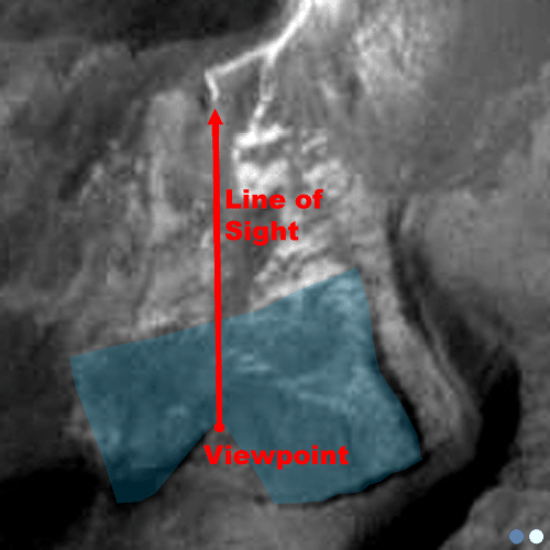
The decisive indication was at first a great surprise for us and also a disappointment.
The magnified image section, on which the two geoglyphs can be seen, indicates, that the floor is not flat.
Note the ridge line, which leads directly below the animal-like geoglyph. It seems plausible
to consider this line as the ground on which the animal lies on. Because of this assumption, it was concluded,
that these geoglyphs were aligned in the same way, as can be seen in the example of the "El Astronauta" geoglyph in Nazca.

Image of the so-called "El Astronauta" geoglyph in the Nazca plains of Peru
The conclusion, however, is wrong. The geoglyphs are not located along a rocky slope, but within a depression.
To recognize that, one need a different view of the surroundings. The original image only provides a two-dimensional
view. The impression of depth and height in colorless gray images can be derived only by
lighter and darker areas of the corresponding surfaces. Shadow and reflection effects are important hint giver and
they convey an impression about the spatial characteristics. An impression that can be deceptive, however.
There are no images that offer a three-dimensional view of this area in the required resolution, but
it is possible to make use of visual tricks here.

Click in image for an enlarged view
Modern image editing programs have transformation functions to create a perspective representation of a two-dimensional image and
tilt it by a certain degree. This technique causes an inclination of an image plane within a seemingly three-dimensional space.
As a result, a new optical impression is possible, which can provide a better recognition of spatial characteristics. It is, as already
mentioned, not a real spatial view.
Newly generated view showing that the Terby geoglyphs lie in a depression
This new insight, however, raises new questions. Why are the geoglyphs located within a depression?
Is there any practical function, when they are right there where they seem to lie? It is important
to clarify especially such issues, in order to show that there is an intelligent purpose and not arbitrariness.
Skeptical observers might still argue that geological processes have created a structure that coincidentally
looks like a person standing on a mythical creature. The more details
are present, that show the influence of artificially induced processes and that also can provide an understandable reason,
the more impressive and convincing can be argued, and thus natural geological processes can be excluded.
Further Traces - Channels and Basins
The one-sided view on the geoglyphs has led to the circumstance that the evironment was not considered in detail any further.
When we take a look on the whole area again, no specific details raises our attention.
The imaged area on the recording is huge. Even large structures would hardly be able to catch the eye.
In addition, in most cases we have a lack of contrast. Considering the fact that the images were checked for unusual structural
anomalies before they were publicated, it is a real lucky strike that this structures have been discovered and have found their
way up to this site.
So a re-examination of that area is necessary, where transformation functions play again an importand role in order to generate
an inclined view of the image plane

Click for an enlarged image
Based on the two-dimensional view, it was quite difficult to get a spatial impression of the area,
but the new view now shows that extensive coherent structures are present here. There is a kind of
canal system and several large sinks, taking the function of a kind of basin.

Click for an enlarged image
If these are indeed artificial canals and basins, then we have to ask ourselves,
for which task one would require such structures. It seems there is just one answer that would be plausible.
Such structures can only be useful for supplying and storing water.
The following view shows the theoretical course of the water flows along the channels to the basins.
The corresponding areas were numbered. Through that it is possible to make a direct reference by using
the appropriate number.

Click on image to enlarge
We can see here for the first time the special significance of the depression, in which the geoglyphs are located.
If we would fill this basin area with water, then the geoglyphs would lie in the water. This points to
a special symbolism, which should be explained in a separate report in detail.
For the moment we should just focus on the functional aspect.
It is important to note that the shown water course is only a theoretical assumption.
On the basis of visual characteristics a water line was drawn here. To these estimates to
verify these assessments, we would need a real three-dimensional view or a height profile depiction
of the area. Further investigations must show whether such data is available or not. Until then, these images
represent a theoretical working model for us. If it turns out that additional data is available
that provides information about how this area is set up in detail, then these data can be compared
with the created working models and they may show whether our prior results are correct or not.
Indications of Processing Tracks
A close examination of the canal and basin structures should now show that there are traces of artificial processing.
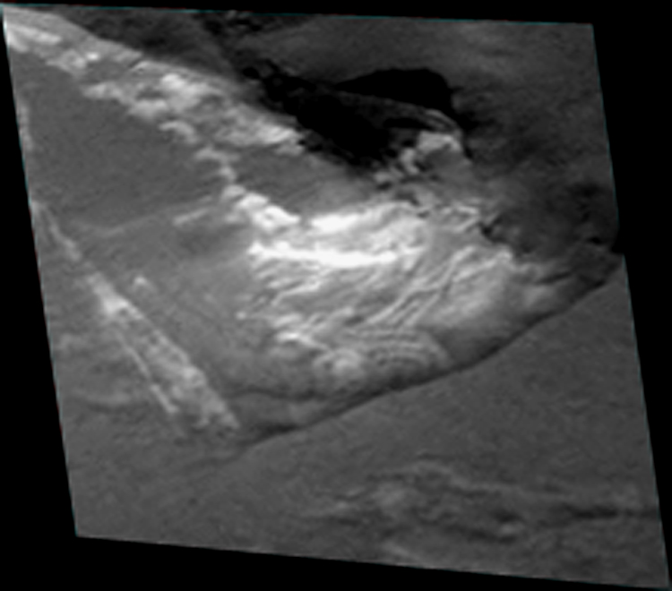
Very interesting in this context is the structure which was identified here as "Basin 2".
If we look at the magnification of the basin we can see that the outline of the basin appears to have a rectangular shape.
Of particular importance are the shadow and reflection effects of the rock surfaces, which are helpful indicators in showing
whether a depression or an elevation is present.
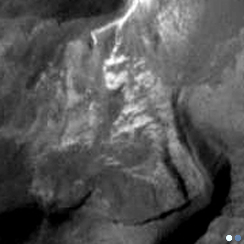
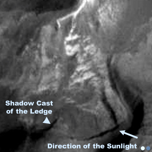
Click in the image to display the markers
A special detail on the shown image is a shadow formation that is located on the lower edge of the basin. The space of the shadow reveals that
there is a ledge that pierces the more rectangular held basin outline and leads into the basin. The shadow width indicates that the ledge has a
correspondingly large distance to the bottom of the basin.
Click in the image to display the markers
If we virtually fill in water into the basin, a triangular-shaped ledge appears. The tip of the ledge almost
reaches to the middle of the basin. This may initially show no practical sense, but instead a very
impressive visual effect would be created. Only an observer, who stands at the tip of this triangular ledge, would be able to get
this special visual impression. If the basin is completely filled with water, as a viewer you would get the impression that
you stand completely detached in the midst of a small lake. It would be a purely aesthetic aspect.
Click in the image to turn on or off the water simulation
This is already very surprising for a supposedly naturally occurring geological rock formation.
But we are still nowhere near the end. There is another stunning detail.
If we now would stand at the top of the ledge and then look straight ahead, our eyes would fall on a rocky slope of a nearby higher
plateau. On the shown illustrations it is possible to see that at the top of the hill there is a narrow white
line structure, that apparently leads around the hillside. At the end of this white line it suddenly bends in a right angle
and its end exactly leads in the direction of the basin. Once again an amazing coincidence. If we assume that the
line structure is a kind of narrow water channel, then this structure would explain, how the water enters the basin.
It would flow down in a kind of waterfall to the basin and the best viewing point for this little aesthetic play would be
precisely at the tip of the triangular ledge.
The following image window visualizes the mentioned details here again. By
repeated clicking on the image a conceptual drawing appears, showing a model of the spatial features.
Click in the image to display the different views
A Water Plant in Terby
A plant for the output and the provision of water would be one of those things to expect, if one assumes
that Mars has been visited by extraterrestrial space travelers. The supply of water is an essential factor
for an independent and sustainable life support in the first place. Whether for drinking for the personal use,
for the irrigation of crops and thus for the production of foodstuffs, for the recovery of oxygen which is
needed for breathing air or as a fuel component, by spliting out the hydrogen from it.
Water can be used in many ways.
Regardless of how different the physiology and biochemical processes of an extraterrestrial life form might be,
it is not unreasonable to suspect that water could also represent a beneficial element for them.
The term 'water plant' is a very general description of what we have here in the north of the Terby crater.
The reconstructions from the area of basin 2 has shown that the plant contains practical aspects as well as
aesthetic aspects. This assumption is supported by the geoglyphs, which have been found within another basin (Basin 1).
These details do not show any practical purpose, but they give the plant a special symbolic meaning. In the light of
these discoveries, we should rather describe it as a water park.
If we now talk about the possibilities of a water system or a water park it prompts the question,
where the water come from? Was there a natural source, or had it to be pumped from the deep?
In that case there should be evidence of some kind of pumping system.
With the aim to precisely clarify the question of the origin of the water, we look again at the site,
for which a summary chart was created, in order to illustrate the possible course of water through the channels and into
the basins. It's surprising, but the task turns out to be quite simple, because everything follows a reasonable
logic. The basins represent endpoints, since water is collected and stored in large quantities. It is possible to
identify the corresponding channels towards the channel, which are responsible for supplying the basins with water.
By following the course of these channels in the reverse direction, we hit again the starting point and thus the source.
It is the point where we expect to find something similar like a pumping system and where we expect to see structural
abnormalities.

To enlarge click on the picture (animated graphic)
The route leads to a location within the area, which has not yet been considered in detail. But exactly this place is
again a further example for a collection of very unusual structures. The enlargement shows several straight lines
and surfaces so that they clearly stand out in a much lighter color against the darker bedrock. In addition, small
punctiform respectively circular structures can be identified, which are in close proximity or even in a conjunction
with a network of fine lines.

Click on image to enlarge
The overview shows that a direct channel connection to 'Basin 1' is not visible. But the new structure, which
is considered to be a potential candidate for the origin of the water flows lies directly at the basin and could therefore also
explain the water supply to this endpoint.
The existence of a water delivery system at this point would be another important discovery that could explain
the function of this entire complex. Water is the central element here. Based on this image, it is
unfortunately not possible to explain the technology that had been used, but we can try to identify the structures
and to compare them with familiar technical equipment we use for the extraction and treatment
of water. It may not be a definite prove for this theoretical explanation model. However, the many details
that mesh here, let natural processes appear increasingly unlikely, and they give serious cause for
assuming that the shown structures have been created with conscious intelligence, showing technical aspects on the one hand and
also artistic aspects on the other hand.
In this case, not many options are available for an image analysis. At first, it is just an assumption, that the new plant
structure is conveyor for water or has something to do with some kind of water treatment. This assumption has emerged from
the fact that the details can be seen in close proximity and within the channel and basin system.
If it is now possible to find conceptual similarities that show similarities with terrestrial examples, then this would
be a further evidence that speak for a water plant.
Channels and basins are relatively simple structures whose function can be quickly revealed.
Relatively simple means might be enough to create such structures. A pumping plant or a plant for water treatment
however needs more advanced knowledge and technology. There may be many ways to build a system with
such a function. Nevertheless there could be similarities with terrestrial plants. Even a
foreign intelligence must deal with the same physical, chemical and biological laws as man.
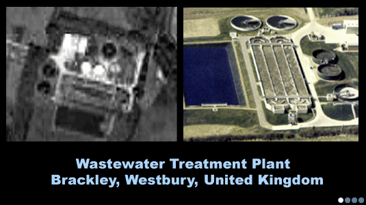
In order to find structural similarities, it makes sense to use images for the comparison,
in which similar conditions are given, regarding parameters as resolution, contrast, or the point of view. For
this task "Google Earth" is suitable. This application uses a number of satellite images, that allows the view on
virtually every desired plant on Earth. In the example used here, the images were further reduced in resolution
and also the color informations has been removed by reducing the saturation. This is intended to create similar conditions
as on the original mars image. Additionally, a regular photo has been attached to the respective examples. The various
examples can be viewed, by just clicking the picture.
Click on the image to display the various examples
The shown plants possess particular characteristics that include, inter alia, circular objects of different sizes, as well as a
plurality of lines, which have right-angled branches. These structures can be trace back to tanks and silos, as well as
pipes and pipe systems. Depending on which process steps has been used, different components are present that influence the
scope and complexity of the plant. Pure pumping systems are quite simple in structure and are
built mostly underground, in which only the
appears above the ground. That's why the aspect of additional water treatment rather meets the present structure.
The examples may serve to provide explanation models for what is seen on the Mars shot. Whether this corresponds to
actual local site conditions can not be explained solely on the present image. The objective is
only to gain the maximum of insights from the Mars images. The more details can be derived, the more likely
it is possible to support the raised theories or to identify errors in logic.
|