Introduction
We encourage you to verify the source images for yourself, rather than just simply accept the facts that are presented here.
Exact details of the used image templates can be found here.
Some reports on this website are based on previous ones. So it is extremely important to read the reports in chronological order.
Details can turn up that were probably already been analyzed in detail. If you are new here and you directly start reading the
recent reports without prior knowledge, then it could happen that the required context is not recognizable.
You do yourself and us a favor when you first start with the oldest reports.
This is the first analysis report regarding the Gusev crater. There are no previous reports. You can continue to read here.
The Mars Rover Spirit
In 2003, NASA started with the space mission "Mars Exploration Rovers" (MER). Two rockets have been launched. Each of them
carried a rover unit. These rovers were designed to examine the surface and geology of Mars.
The two rovers have been christened with the names Spirit (MER-A) and Opportunity (MER-B).
The mission plan can be now considered as a great scientific success.
Both rovers have exceeded their planned operation time and have provided many new insights about Mars.
Due to persistent technical problems, NASA has given up the communication with the Spirit (MER-A) on 25 May 2011,
Opportunity, however, is still on the road and provides interesting images and measurement data from the Martian surface.
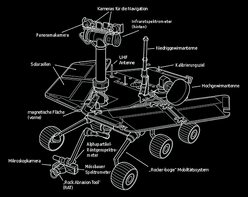
Click on image to enlarge
The assembly of both rover is identical. Each of them is equipped with several camera systems that were built for various purposes:
The Panoramic Camera (Pancam) - Used to determine the texture, color, mineralogy and structure of the local terrain. Actually,
this camera system consists of two high-resolution color CCD cameras
 ,
mounted as a stereo pair at a distance of 30 centimeters on a swinging arm at a height of 1.50 m.
The arm can rotate 360 degrees around and allows a complete panoramic view. ,
mounted as a stereo pair at a distance of 30 centimeters on a swinging arm at a height of 1.50 m.
The arm can rotate 360 degrees around and allows a complete panoramic view.
A Navigation Camera (Navcam) - It has a larger field of view, but a lower resolution
and can create monochrome images only. It is specifically designed for navigation of the rover, and also has been implemented
stereo pair camera system.
Four Hazard Avoidance Cameras (Hazcams) - They are attached at the lower front and rear of the rover. These cameras
serve as a protection system to obtain an accurate view of the position of the rover, if it encounters unforeseen obstacles.
The cameras also have a relatively wide field of view. They are directly installed into the body of the rover, so
a view angle control of these cameras is not possible.
An important issue regarding the time measurement on Mars:
A Martian day is longer than an Earth day. It is exactly 24 hours, 39 minutes and 35 seconds. For the labeling
of an extra-terrestrial planet day the term SOL came in use. Thus, the images of the rovers
are marked with the respective SOL-time.
Spirit's Operational Area - The Gusev Crater
Three weeks prior to his identical twin Opportunity Spirit landed successfully on 4 January 2004 on Mars.
The Gusev crater was selected as operational area for the Mars rovers Spirit. Geological and mineralogical evidence suggests
that probably once large amounts of water came into the Gusev crater from the south through the Ma'adim Vallis canyon. Probably
the crater was once completely covered with water. Thus, the search for clues of past water activities was one
of Spirit's mission objectives. An analysis of rock samples should show, whether minerals were deposited,
caused by water or through subsequent processes such as precipitation, evaporation, cementation, or hydrothermal activity.
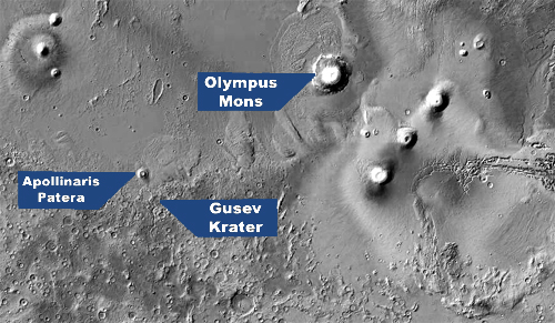
Click on the image to recieve an enlarged view of the Gusev Crater area
The name Ma'adim originates from the Hebrew and stands for Mars. The canyon with the same name has a total length of 700 km,
an average width of 20 km and a depth of 2 km.
From a southern lowland region, that probably possessed several large lakes, it leads to the north into the Gusev Crater near the equator.
The menu option "Anomaly Map" provides an overview of the Martian surface. The option
can also be called by clicking the right mouse button.
Structure Anomaly - A Stone Hill within the Gusev Crater
The transmitted images of both two Mars rovers have been made available via the Internet to the public.
The image shown below was made by Spirit's panoramic camera on Sol 728.
It represents an enlarged detail of the original recording, that served as the basis for the
following studies.
Details of where the original images can be downloaded are listed on the page
image templates within the project area of this Website.
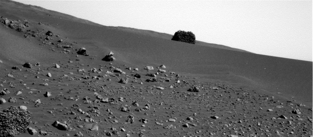
Click on image to enlarge
The structure is quite unique in its appearance. So far, no Mars rover has ever discovered such a prominent stone hill protruding from the landscape.
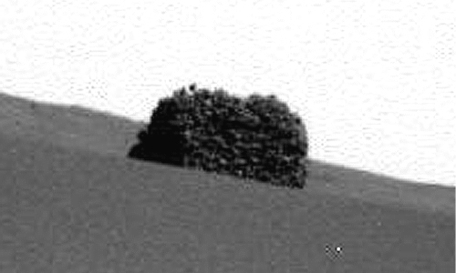
Click on image to enlarge
Structure Analysis
The following image analysis shows that this is not just simply a single massive rock.
You may click here on the image to get different filtering views.
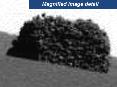
Click on image in order to get a new filtered view
The magnified section shows rather well that the hill is not uniformly structured, but it seems to consist of several individual pieces.
The brightness and contrast enhanced view can confirm this impression and the sun-drenched areas and the corresponding
shadows form a very inhomogeneous pattern, which in turn suggests that the cairn is composed of several layers of stone.
This fact becomes especially clear when in addition the contours values are highlighted. The resulting contours pattern shows here very
impressively the individual superimposed structures.
NASA's Response
It raises the question of how such a structure can arise in a natural way. In this shape, such a stone hill is a very interesting
geological phenomenon that needs a closer examination. How, then, have the NASA researchers reacted, when they found this unusual structure?
No response!
It is not clear why this "stone hill" has in any way not aroused the interest of the NASA scientists. In many cases, less conspicuous
stone and rock structures have been closely scrutinized of by the Mars rovers and occasionally samples were taken. This outstanding structure was,
however, simply ignored. The recording Spirit that had been made on sol 728, for example, shows highly visible the stone hill at the top center of the image.
Over several days this conspicuous hill is visible on various recordings. This opportunity would have provided revealing insights
that would have allowed the explaination of how such a stone hill can emerge.
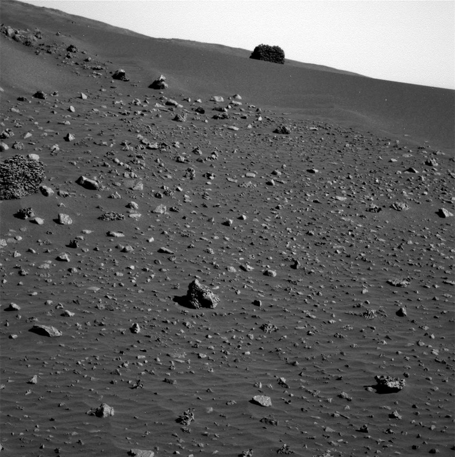
Click on image to enlarge
The following image shows very impressively, how the stone hill stands out from its surroundings.
It is very unlikely that this structural anomaly has been overlooked for several days. Especially as the images are always
viewed and analyzed by a team of scientists and the route of the rover does not take place by ad hoc actions.
The opposite is the case. It seems that the hill was selectively targeted, because
a closer examination of the available images reveals that the hill can be traced back to a longer period of days.
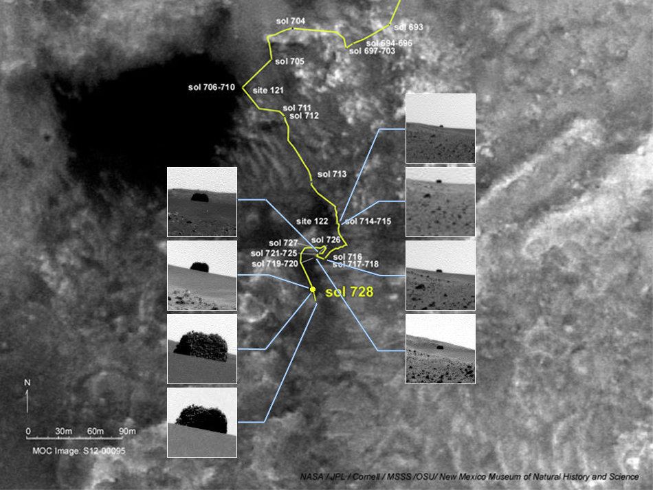
Click on image to enlarge
The hill on Sol 714 can just be seen from far away. By using a
Traverse Map  that the JPL
  has made available on their official website, the path of Mars Rovers can be traced back.
Further information, if necessary, can be derived from these maps. Since the hill continually increases and on the corresponding
images of the rover are no wheel tracks visible, the hill must be located in southern direction. Despite the course changes
that led further west during SOL 716, images that show this stone hill were still produced. This is only explainable by rotating
the camera frame, in which the navigation and panoramic cameras were installed.
Considering the available data, it can be concluded that this stone hill definitely has attracted the attention of NASA researchers
and has not been accidentally overlooked. In nineteen shots, this structural anomaly is visible over a period
of 16 days and has been recorded with the panoramic camera, as well as with the navigation camera. The officially documented route
of the rover leads even closer to the presumed position of the hill, but nevertheless there are no more images of the stone hill from Sol 730 on.
Bearing in mind that, regardless of the chosen course, images were consecutively present starting from Sol 714, but now it is very striking that
the series of these hill images abruptly ended at Sol 730. Thereafter at none of the following days the hill can be discovered again. Even if
the course leads the rover further away from the hill, one would expect to see a decreasing hill sporadically on some of the images.
The images show on the day of the last recording at Sol 730 no visible obstacles that might have called for closer examination into question.
From a scientific point of view it is not clear why there was at least no attempt to drive closer to the structure. However, this action
is explained when you make yourself aware what may have come out to the public, if they had made further detailed studies here.
Namely, that such a hill can not arise naturally.
An interesting parallel at this point are stone hill constructs that can be found here on Earth.
The connection, that can be created here, is part of a further report. With a focus on cultural aspects, earthly stone hill constructs, known as Cairns,
should be further investigated.
|

